


 |
| Of course, another panorama |
 |
| Here's one for Tom Ryan--down LOW. |
After leaving that beach, I tried to figure out how to get north, but quickly realized I'd have to backtrack quite a ways. I was hoping to be at Rialto Beach at low tide, but now it was looking like I'd be getting there a bit after the lowest tide, and therefore as it was coming back in.
We arrived at the parking area, and it was nice that there was no payment required. We'd paid to get into the Hoh Rain Forest the day before, and the receipt is good for entry into the same national park for seven days, but it was nice just to not have the hassle. Though it WAS crowded. There was a ranger there talking to several people, and he had what looked like a tide table in his hands. But we passed him by and headed to the beach.
Some people had already stacked (and were still stacking) cairns all over the logs. It was pretty cool.

So of course Nathan joined in the fun and stacked a pile of his own.
 |
| The artist, admiring his work |


I had gradually been noticing that there were FAR more people heading back toward the trailhead than heading out from the trailhead with us. (Even accounting for the fact you pass more people head-on than you pass or are passed by going the same direction--I stopped and looked around, and there were far more people headed north than south.) I wondered if they knew something I didn't about the accessibility of the "trail" which, thus far, was just the beach) at high tide, which was approaching soonish. So after conferring with Nathan, and considering what else we still wanted to get to see, we turned around and took more pictures heading back the way we'd come.


 |
| Nathan found a ladybug |


After our little hike, we got back on the road and headed toward Port Angeles. Along the way, we passed Crescent Lake, a beautiful blue lake. We stopped once, at a campground/resort area, and got out and took a few pictures, but then hit the road again.


In Port Angeles, we only briefly stopped for gas and a snack at Safeway, then headed up to Hurricane Ridge. I seem to recall being there on a family vacation when I was a kid, and at that time (also in the summer, but maybe earlier in the summer, like June or July), and it totally lived up to its name. However, this time, it was absolutely beautiful weather, and showed off the beautiful view.
 |
| This is stitched from multiple photos, taken at an overlook partway up the hill |
 |
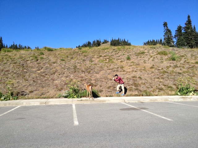
| The view from the visitor center, including a deer grazing in the big meadow |
There was a cache just a few blocks away, so we headed in that direction, but it turns out the cache was accessible only off a waterfront trail that was several stories lower than us down a STEEP hill covered in blackberry bushes. Sure enough, when I zoomed in on the satellite map view in my phone app, all the nearby caches were on that same trail. So we headed toward the closest one we could easily get to, which also happened to be the destination I had in mind--a cache large enough to drop a trackable I'd created recently (added a keychain from Hurricane Ridge to a trackable tag I purchased and activated).
 |
| This boat was parked alongside the road just about when we realized we couldn't get to the cache we originally intended |

The site of the cache had a few "muggles," both human and otherwise:


 |
| I stood around taking pictures, trying to look like a mom who wasn't paying much attention to her kid who was crawling around in the bushes amidst the litter (while Nathan looked for the cache) |

 |
| This was called the "Rocktopus" |

We headed back up the trail toward the cache we'd originally headed for, and found one cache, but it was starting to get dark, and Nathan was getting cold, so we didn't make it all the way to that cache. Oh well.
On our way back, we saw a motel with an interesting name.


ah, cool you're a cacher too - i was enjoying these posts and suddenly saw that you were caching. my man and i also cache the olympic peninsula every time we visit home, cuz my dad lives over there.
ReplyDeleteYep, gives me a reason to get out and get hiking when I'm at home (don't need much motivation around here--lots of pretty scenery).
Delete